Thursday, 31 March 2011

Streets of Paris & Virtual Locations of History


Quite happily for me, my research always seems to lead me back to the streets of Paris. Recently I was taking photos of rue des Bons Enfants for some research I've been doing on the suicide of the painter, François Lemoyne, who lived on the street in the 1730s. And more generally I've been undertaking a lot of mapping work to reconstruct the local social networks of artists living in the parishes of Paris during the eighteenth century (of which more soon!).

I've come across various websites collecting and presenting information about the streets of Paris, like Les rues de Paris and Le Paris Pittoresque, which have historical blurbs and photos of individual streets. Les rues de Paris provides a sense of an on-going lived history with recent photos and current business listings alongside historical information, while Le Paris Pittoresque entries are usually transcriptions of nineteenth-century street histories like Histoire de Paris rue par rue, maison par maison (1875), or Louis Lurine's Les rues de Paris. Paris ancien et moderne (1844).
Les rues de Paris

While the information that sites like this contain is useful, they don't offer quite the virtual experience that I'm after. Both sites are unfortunately fairly inundated with ads, and have rather unappealing lay-outs, which makes the armchair travelling experience less pleasant than it otherwise could be. In the lists of streets, bullet points of data, and separate pages, there may be information, but there's little sense of place, and no sense of connections between places. You don't get to walk the streets of Paris here.

By contrast, one of the most successful and engaging online local history projects I've come across recently is about the streets of Philadelphia rather than the streets of Paris... the interactive website PhilaPlace, made by the Historical Society of Philadelphia. 

PhilaPlace
Using images, text, video, audio and historical maps, the site connects history and place at a local level, or as they put it: "PhilaPlace weaves stories shared by ordinary people of all backgrounds with historical records to present an interpretive picture of the rich history, culture, and architecture of our neighborhoods, past and present."

Tour on PhilaPlace
Navigating your way around town using historical maps, you feel like you're exploring the city both geographically and through layers of time. You can move through the past by selecting different maps - from the contemporary Googlemap, to earlier ones from 1962, 1935, 1895 and 1875 - giving an impression of the changing size and structure of the urban environment. All of these maps are pinned with the same points of interest - including churches, historical buildings, well-known businesses and cemeteries - offering a sense of the history of these urban spaces, and the shifts and continuities in the communities that have lived there. Each place has a description and several images from different moments (black & white or colour depending on the period), showing either the building, street views, or images of Philadelphians using the place. You can filter the points of interest to show specific themes (e.g. 'health', 'immigration', or 'religious life'), and if you can't decide how to wander the streets yourself, you can take a guided tour! (only two at the moment, but presumably more are coming).

I've never actually been to Philadelphia, but I have a more intimate sense of its local history now than I do of many places I have visited. In a way, it's like a 21st-century version of Richard Cobb's wonderful essay, The Streets of Paris (1980)... using word and image to capture the history of place... but doing it interactively. Now if we could just do this for Paris...


Sunday, 20 February 2011

Google Arting About: an art historian's perspective on Google Art Project


I got talking with some non-art historians one lunchtime this week about Google Art Project and its applications for art historical research. Most of them were quite surprised that I didn't just think it was a silly toy for amateurs. But really, what's not to like about making art history feel like play!?

For most people, visiting a museum (especially when overseas) is a tourist experience; for me, it's usually work, but that doesn't mean I don't enjoy it. Research trips are fun but they are still research. So if Google Art is for the most part about giving people the chance to be 'virtual tourists', then I don't see why it doesn't give me the same chance to be a 'virtual researcher'.

Not only is it great to be able to visit museum collections that I've never had the opportunity of visiting in the flesh, like the Hermitage, but also the resolution of the images makes it a really useful art viewer. There's just no way you can get that level of detail (particularly brushwork) in most images on the internet (with a few exceptions like the National Gallery's zoomy viewer). For me, the detail really is the highlight. Art historians are often interested in less obvious details than those that are usually photographed - Google Art means you can zoom on all kinds of weird things, take a screenshot, and throw it into a Powerpoint presentation for your next class or conference paper.

Another thing I was particularly excited about was not just 'visiting' galleries I'd never been to, but seeing old favourites in new ways... that is, in ways not possible when you're standing in the room. I've been doing some work on François Lemoyne recently, so when I first had a play with Google Art I went straight to Versailles to hunt out the Apotheosis of Hercules that he painted on the ceiling of the Hercules Salon. I've spent many hours standing in that room being jostled by hundreds of tourists, straining my neck and nearly falling over backwards to try and see Lemoyne's painting. And forget photographing it, that's always a complete blurry and piecemeal disaster.

But here it is on Google Art, in amazing high resolution that allows you to zoom in on the details in a way that would never be possible in real life... while also being situated in its original setting, so you don't forget how it was supposed to be viewed and experienced. This way I'm able to consider not only its reception, but also its production: I get to experience how the courtiers saw it from the ground, but also to see it with the proximity that Lemoyne did from the scaffolding when he was painting it. (As an aside - the only problem with this at the moment is that only half the ceiling has been photographed... I'm hoping this will be amended in the fullness of time).

With the Versailles example, once again I can see how it's going to become a really useful teaching and presentation tool. I can take a screen shot of the room and the floor plan, showing exactly where in the palace the painting is so I can show students and others who haven't had the chance to see it in situ for themselves. How great will that be for teaching museum studies and curating courses, giving students a virtual experience of the space and the context of its location in the museum all at once? Of course, in this respect, one of the pros is also one of the cons... it may be an art historian's relief to see the Mona Lisa without crowds of tourists, but it's certainly not an authentic experience of the object from a museological perspective.

Google Art is not flawless and it's not free of issues... but for the art historian, it's fun, useful and exciting. And that's enough for me.

Tuesday, 8 February 2011

The last jube in Paris

No, not the sweet. I'm talking about architectural jubes, what the French call a jubé and what is better known in English as a rood screen. This is the architectural element of a church that physically separates the choir from the nave, and hierarchically separates the clergy from the laity during a service. The word comes from the Latin phrase intoned by the celebrant before preaching: "Jube, Domine, Benedicere..."

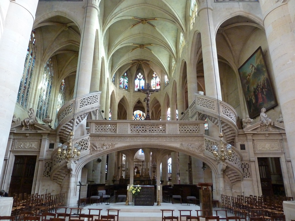
I've just returned from a research trip to Paris, where I visited the church of Saint-Étienne-du-Mont (right next door to the Panthéon in the 5th arrondissement), and witnessed first-hand the last jubé still intact in a Paris church.


It was built around 1530-45 by Antoine Beaucorps. The impression it makes on the space of the church is incredible - this huge mass of stone which seems to lightly twirl itself around a couple of columns. It's known for its stylistic eclecticism, combining organic Renaissance decorative elements on a much more Gothic structure, something which was presumably attracting the numerous architecture students sitting sketching it from the nave while I was there (though I managed to hide them behind a column when taking the photograph).

Jubés were mostly removed from French churches during the Counter Reformation, following those decrees from the Council of Trent that emphasised the importance of making the Mass accessible to the congregation. The jubé wasn't actually condemned by the Council, but its removal was interpreted as a way of quite literally breaking down the barrier that separated the people from the sacred actions of the service. If the jubé of Saint-Étienne-du-Mont is anything to go by, then all I can say is: what a pity!

Thursday, 6 January 2011

A Versailles Meta-Moment

 Photo Credit: Château de Versailles

I think this is just fabulous! It's a photograph taken in the Jeu de Paume court at Versailles in 2010 during a conference (pdf) on the oath taken in the Jeu de Paume court at Versailles in 1789. A coloured reproduction based on Jacques-Louis David's Tennis Court Oath completes the whole meta mise-en-abyme experience. Brilliant. Talk about retrieving layers of time through space and place.

Wednesday, 29 December 2010

Historical Social-Networking

Just found this very exciting new resource that has come out of a project trying to create a kind of historical ‘Facebook’ of medieval Scotland. Using primary documents (mostly charters), historians at the Universities of Glasgow, Edinburgh and King’s College London have created a database of ‘all known people’ in Scotland from the years 1093 to 1286.

Medieval Scotland isn’t exactly my place or period but I’m excited by the project because the idea of using social media technology to understand historical social networks and human interactions is something that really interests me. Last year I attended a launch event at the Science Museum in London for a competition in conjunction with their Cosmos and Culture exhibition, where participants were invited to come up with ways of using the museum's collections data to create a website. I wasn't really there as a contender, but I had lots of fun brainstorming ideas with those who were. Being more of a cultural/social historian than a science historian, what I was most keen on was the idea of tracing the social networks between scientists and other people in their historical contexts - making a 'Facebook' of the past (you can see our nascent efforts down the bottom on the ideas board next to Caroline Herschel, who paid an inspirational visit from 1797).

Photo Credit: Mia Ridge

In my own research on 17th-/18th-century French artists in Paris, social-networking has often proved a useful analogy as I imagine something like a LinkedIn of the 18C art world: who knew who? in what capacity? for how long? where did they meet? etc etc. Thanks to the Paradox of Medieval Scotland project, I’m now even more convinced that there might be a way of actually using social media web-technologies to map the social networks in which artists moved… not only providing a way of visualising relationships in artistic communities, but actually allowing us to discover hitherto unobserved connections between people.

Tuesday, 21 December 2010

Maybe it's not so cold afterall...

I was shivering looking at the snow outside in Oxford and wondering (as I often do) how they coped in the 18thC without central heating and double glazing...

And then I did a little googling and realised I had nothing at all to complain about. Who knew it was so much colder in the 18thC!

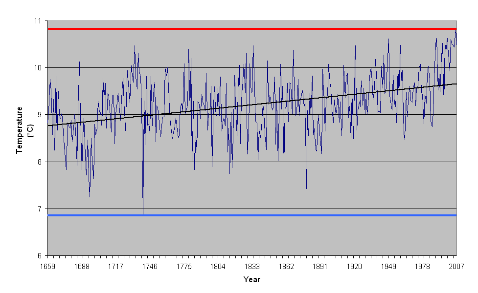
According to the Central England Temperature (CET) record, the coldest year ever was 1740 (with a very mean mean temperature of 6.84C), the coldest ever month was January 1795 (with a mean temperature of -3.1C), and the coldest winter was 1684 (with a mean temperature from Dec-Feb of -1.17C). The 18thC even boasts the record for the coldest summer, which was in 1725 (with a mean temperature of 13.1C).

The last days of 2010 feel practically balmy now...